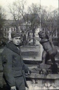
 This post shares a more personal digital story in a new way. For the past two years, I’ve been helping my great-uncle transcribe written journals into a historic memoir. His memoir, “As I Saw It: The Story of GI’s in World War II” is a day-by-day account of his service in World War II. The picture on the left is my uncle on the day he enlisted in the infantry regiment.
My great-uncle, William C. Lagos — or Uncle Bill, to me — is now 92. In 1943, he was supposed to be attending college at the University of Wyoming, but then joined the U.S. Army as a communication sergeant. Over the next two years, he wrote everyday about his enlistment, training and eventually, action in the European Conflict.
This historic story is truly interesting to read, but since the war zone stretched thousands of miles, it is difficult to visualize how far my great-uncle walked while serving in the war. By telling his story visually through the use of a Google Map, I was able to turn my great-uncle’s memoir into a digital story.
The Google Map has three layers for easy differentiation. The first layer — the blue markers — represent a time before the war. The second layer — the green markers — represent his time training. The third layer — the red markers — represent his time overseas.
Each marker holds a piece of the memoir from tough training in high temperatures to drinking champagne due to a shortage of water.

